
Bordeaux to Geneva 2026
Contents
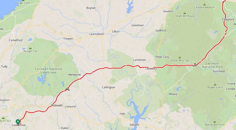
Day 1: Bordeaux to Bergerac
Day 2: Bergerac to La Roque-Gageac
Day 3 La Roque-Gageac to Beaulieu-Sur-Dordogne
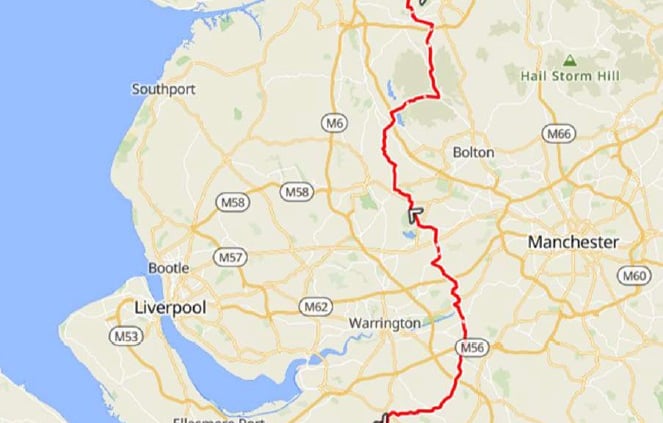
Day 4: Beaulieu-Sur-Dordogne to Mauriac
Day 5: Mauriac to Murat
Day 6: Rest day in Murat
Day 7: Murat to Brioude
Day 8: Brioude to Le-Puy-en-Vellay
Day 9: Le-Puy-en-Vellay to Le Chambon-sur-Lignon
Day 10: Le Chambon-sur-Lignon to Tournon-sur-Rhone
Day 11: Tournon-sur-Rhone to La Cote Saint Andre
Day 12: La Cote Saint Andre to Chanaz
Day 13: Chanaz to Geneva
In 2025 I had undertaken two fairly challenging trips which provided the satisfaction of completing them but were sufficiently arduous that cycling, eating and sleeping were the dominant activities although plenty of photos were taken along the way. The Bordeaux - Geneva trip is in the Bike Adventures "regular" category and should be less arduous.
Preparations
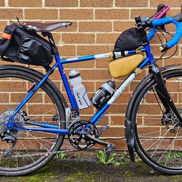
After the Italian trip I had bought another bike to add to my collection. This was a Boardman ADV 8.9 which is very good value when on sale for £1,400 (which is why I bought it). I knew that the Shimano GRX400 drivetrain will work with a 11-42 cassette which my legs would welcome while the overall weight is around 1kg less than the bike I used in 2025. I therefore decided that this relatively cheap bike would be the candidate for my 2026 cycling trips and I rode it during the winter to both give it a thorough test and stop looking like a new bike.
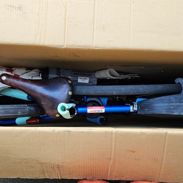
Having got the bike sorted the next challenge was deciding which saddle to use. The leather Selle Anatomica saddle used in Italy had noticeably deformed after a good soaking although it still remained comfortable. I clocked up a lot of miles on a 3D printed Specialized Phenom Pro Mirror saddle which looked to be a good candidate as it incorporated some ventilation and wouldn't be affected by rain. Unfortunately, as the weather turned warmer I discovered that the saddle became softer and less comfortable. By then I had acquired a heavier duty version of the saddle used in Italy so more miles were spent trying to get this into the right shape before deeming it OK to put on the Boardman.
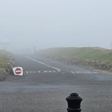
As with the previous trips the bike travelled in a box to Bike Adventures for transport to the start while I booked a train ticket to Gatwick airport and the EasyJet flight to Bordeaux. The days before departure were a record-breaking heatwave both at home and in France which caused frequent anxious checks on the weather forecasts.
Day 1: Bordeaux to Bergerac
Day 1 (28th June) Summary
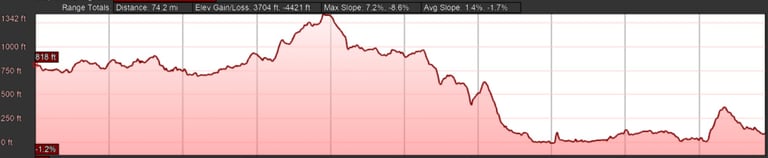
Distance 62.8 miles: Total Ascent = 750m (2,460ft)*
Elapsed time = hrs mins: Moving time = hrs mins
Average moving speed = mph
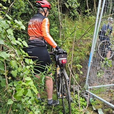
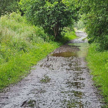
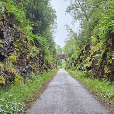
This was the longest day of the trip but relatively easy terrain including over 20 miles along a former railway. The French have been somewhat better than the British in keeping public ownership of closed railways so many were easily converted to good cycling routes.
Day 2: Bergerac to La Roque-Gageac
Day 2 (29th June) Summary
Distance 51.3 miles: Total Ascent = 1,040m (3,400ft)*
Elapsed time = hrs mins: Moving time = hrs mins
Average moving speed = mph
*Ascent according to my Garmin Edge 1040 which usually agrees closely with Google Earth. My Edge 530 usually records about 15% less climbing which is more consistent with RWGPS. I assume that the newer hardware is more accurate.
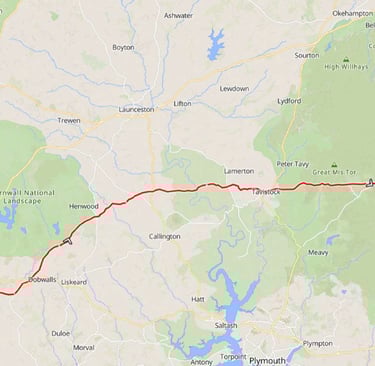
Day 3: La Roque-Gageac to Beaulieu-sur-Dordogne
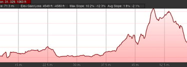
Day 3 (30th June) Summary
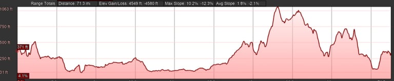
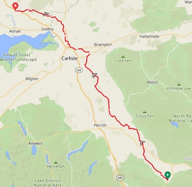
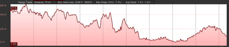
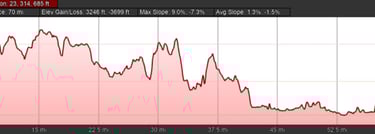
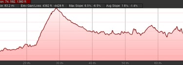
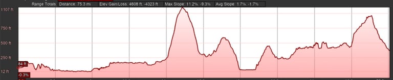
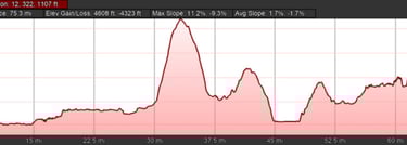
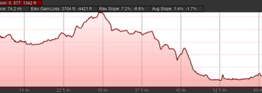
Distance 58.2 miles: Total Ascent =1,680m (5,500ft)*
Elapsed time = 7hrs 15 mins : Moving time = 5hrs 25 mins
Average moving speed = 10.8 mph
*Ascent according to my Garmin Edge 1040 which usually agrees closely with Google Earth. My Edge 530 usually records about 15% less climbing which is more consistent with RWGPS. I assume that the newer hardware is more accurate.
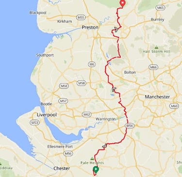
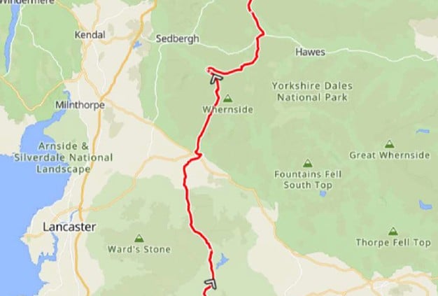
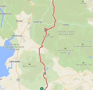
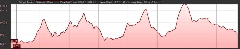
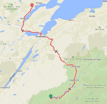
Day 4: Beaulieu-sur-Dordogne to Mauriac
Day 4 (1st July) Summary
Distance 47.4 miles: Total Ascent = 1,400m (4,500ft)*
Elapsed time = hrs mins: Moving time = hrs mins
Average moving speed = mph
*Ascent according to my Garmin Edge 1040 which usually agrees closely with Google Earth. My Edge 530 usually records about 15% less climbing which is more consistent with RWGPS. I assume that the newer hardware is more accurate.
Half way through the day there's a substantial climb of about 500m out of the Dordogne river valley and onto higher ground.
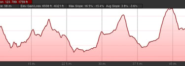
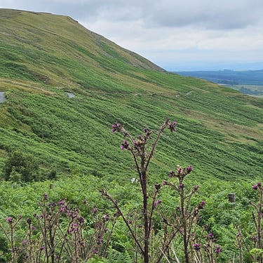
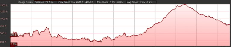
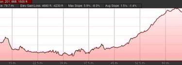
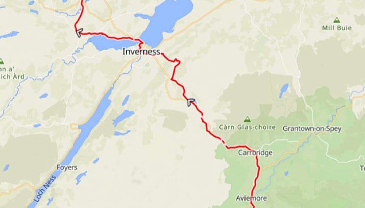
Day 5: Mauriac to Murat
Day 5 (2nd July) Summary
Distance 38.2 miles: Total Ascent = 1,480m (4,850ft)*
Elapsed time = hrs mins : Moving time = hrs mins
Average moving speed =11 mph
*Ascent according to my Garmin Edge 1040 which usually agrees closely with Google Earth. My Edge 530 usually records about 15% less climbing which is more consistent with RWGPS. I assume that the newer hardware is more accurate.
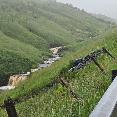
This day includes the physical high point of the trip which is Le Puy Mary at nearly 1,600m elevation.
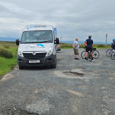
Day 6: Rest day in Murat
3rd July
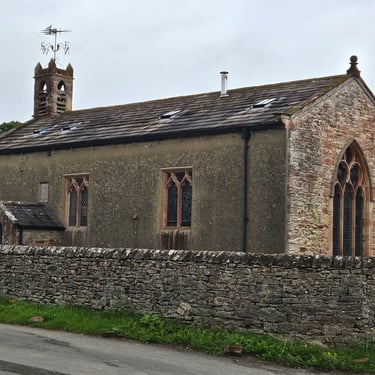
This day provides an opportunity for laundry, bike maintenance and searching for what is on offer in a not very big town. Wikipedia says that the population is less than 2,000 and there is a market on Fridays.
Day 7: Murat to Brioude
Day 7 (4th July) Summary
Distance 47.1 miles: Total Ascent = 970 m (3,150ft)*
Elapsed time = hrs mins : Moving time = hrs mins
Average moving speed = mph
*Ascent according to my Garmin Edge 1040 which usually agrees closely with Google Earth. My Edge 530 usually records about 15% less climbing which is more consistent with RWGPS. I assume that the newer hardware is more accurate.
Day 8: Brioude to Le Puy-en-Velley
Day 8 (5th July) Summary
Distance 41.9 miles: Total Ascent = 1,200m (3,800ft)*
Elapsed time = hrs mins : Moving time = hrs mins
Average moving speed = mph
*Ascent according to my Garmin Edge 1040 which usually agrees closely with Google Earth. My Edge 530 usually records about 15% less climbing which is more consistent with RWGPS. I assume that the newer hardware is more accurate.
Day 9: Le Puy-en-Velley to Le Chambon-sur-Lignon
Day 9 (6th July) Summary
Distance 35.3 miles: Total Ascent = 1,100m 3,500ft)*
Elapsed time = 7 hrs 9s min: Moving time = 6 hrs 24 mins
Average moving speed = 11.1 mph
*Ascent according to my Garmin Edge 1040 which usually agrees closely with Google Earth. My Edge 530 usually records about 15% less climbing which is more consistent with RWGPS. I assume that the newer hardware is more accurate.
Day 10: Le Chambon-sur-Lignon to Tournon-sur-Rhone
Day 10 (7th July) Summary
Distance 49.3 miles: Total Ascent = 1,100m (3,700ft)*
Elapsed time = hrs mins : Moving time = hrs mins
Average moving speed = mph 11.2mph
*Ascent according to my Garmin Edge 1040 which usually agrees closely with Google Earth. My Edge 530 usually records about 15% less climbing which is more consistent with RWGPS. I assume that the newer hardware is more accurate.

Day 11: Tournon-sur-Rhone to La Cote-Saint-Andre
Day 11 (8th July) Summary
Distance 47.2 miles: Total Ascent = 760m (2,500ft)*
Elapsed time = hrs min : Moving time = hrs 4 mins
Average moving speed = mph
*Ascent according to my Garmin Edge 1040 which usually agrees closely with Google Earth. My Edge 530 usually records about 15% less climbing which is more consistent with RWGPS. I assume that the newer hardware is more accurate.
Day 12: La Cote-Saint-Andre to Chanaz
Day 12 (9th July) Summary
Distance 56 miles: Total Ascent = 800m (2,600ft)*
Elapsed time = hrs mins : Moving time = hrs mins
Average moving speed = mph
*Ascent according to my Garmin Edge 1040 which usually agrees closely with Google Earth. My Edge 530 usually records about 15% less climbing which is more consistent with RWGPS. I assume that the newer hardware is more accurate.
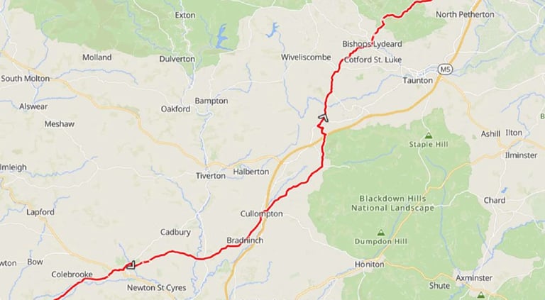
Day 13: Chanaz to Geneva
Day 13 (10th July) Summary
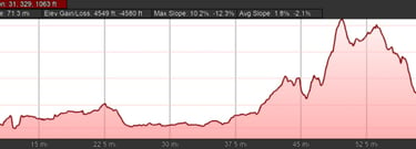
Distance 49.3 miles: Total Ascent = 1,350m (4,400ft)*
Elapsed time = hrs mins : Moving time = hrs mins
Average moving speed = mph
*Ascent according to my Garmin Edge 1040 which usually agrees closely with Google Earth. My Edge 530 usually records about 15% less climbing which is more consistent with RWGPS. I assume that the newer hardware is more accurate.
The Journey Home and Concluding Remarks
I have booked the EasyJet flight from Geneva to Gatwick and train for the final part of the journey. Fingers crossed that the EES doesn't cause me to miss the flight.
Copyright John Ratsey 2025.