The Danube Explorer 2026
Contents


This is my second 2026 Bike Adventures trip the first being Bordeaux to Geneva trip where there were some uncomfortably hot days and a few relatively big climbs. The Danube Explorer trip offers fewer hills but greater daily distances. I wait to see if the weather is amenable.
Preparations
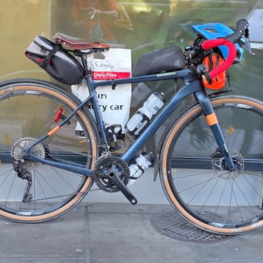
After the Italian trip I had bought another bike to add to my collection. This was a Boardman ADV 8.9 which is very good value when on sale for £1,400 (which is why I bought it). I knew that the Shimano GRX400 drivetrain will work with a 11-42 cassette which my legs would welcome while the overall weight is around 1kg less than the bike I used in 2025. I therefore decided that this relatively cheap bike would be the candidate for my 2026 cycling trips and I rode it during the winter to both give it a thorough test and stop looking like a new bike.
Having got the bike sorted the next challenge was deciding which saddle to use. The leather Selle Anatomica saddle used in Italy had noticeably deformed after a good soaking although it still remained comfortable. I clocked up a lot of miles on a 3D printed Specialized Phenom Pro Mirror saddle which looked to be a good candidate as it incorporated some ventilation and wouldn't be affected by rain. Unfortunately, as the weather turned warmer I discovered that the saddle became softer and less comfortable. By then I had acquired a heavier duty version of the saddle used in Italy so more miles were spent trying to get this into the right shape before deeming it OK to put on the Boardman.

Day 1: Donauschingen to Sigmaringen
Day 1 (28th July) Summary
Distance 64.1 miles: Total Ascent = 550m (1,800ft)*
Elapsed time = 6 hrs 35 mins: Moving time = 5 hrs 22 mins
Average moving speed = 12.0 mph


This was the longest day of the trip in terms of distance but with relatively easy terrain including nearly 20 miles along a former railway. The French have been somewhat better than the British in keeping public ownership of the land occupied by closed railways so many were easily converted to good cycling routes. The hills look big but the vertical scale on the profile is 0 to 100m.
An overnight thunderstorm coincided with a very noticeable drop in temperature compared with the previous week or more. My Garmin watch told me that I was more knackered than usual after a not very good night's sleep. I don't like thick duvets or very thick pillows and I hadn't had time to get the air conditioning to my liking. The group comprised nine cyclists with two leaders, one of whom would cycle with the group. There should have been more, but four participants had withdrawn for various reasons. I knew seven of the participants and both leaders from previous trips so it didn't take me long to sort of faces and names.
After a general briefing we departed from the hotel at about 08:15 and followed one of the leaders as the initial part of the route was different to that provided due to road changes. First stop was in front of the railway station for a group photo before crossing the Garonne river after which we were back on route. The first few miles were on a riverside path after which we joined the cycle path along the old railway. It was relatively busy with other cyclists, runners and walkers taking their Sunday exercise. Most of the route along the railway path was heavily shaded by trees which kept that section comfortably cool at around 20°C. A curved old railway tunnel was even cooler. The generous size compared with British railway tunnels was very noticeable.
The first hill was a very gentle climb at railway gradients to the town of Creon where we stopped. Most people had refreshments while I bought a cheese and ham baguette for a picnic lunch before continuing along the railway path which, my body was starting a little tedious due to the fairly constant position and effort although it was a very pleasant environment. At 23 miles the route turned off the cycle path and went northwards in search of the Dordogne river which would be our companion for the next three days. The river was a very brown colour when first encountered, presumably due to sediment washed in by a recent thunderstorm. Trash on the piers of a bridge a few miles further on showed that large floods can occur.
The day's destination was the Bergerac Ibis Budget hotel in a business part on the edge of the city. By the time I arrived at nearly 3pm the outside temperature was about 29°C (as measured by my Garmin Tempe temperature sensor fitted under the stem out of direct sunlight which causes the Garmin Edge to report even higher temperatures). While the hotel rooms were functional there was a strong hint of budget with the air conditioning refusing to go below 23°C. There was an adjacent McDonald's but the van took two loads of cyclists into the city in search of better food. Arrival at 6:15pm resulted in a fair amount of wandering around searching for food as all the restaurants asked didn't start serving until 7pm. And, once finally fed, we had to arrange taxis to get us back to the hotel. Fortunately, group member Susie was fluent in French and got transport arranged although we had to wait nearly half an hour for it to appear. Sunday evening isn't a good time for catching taxis.


Day 2: Sigmaringen to Ulm
Day 2 (29th July) Summary
Distance 51.3 miles: Total Ascent = 700m (2,300ft)*
Elapsed time = 5 hrs 56 mins: Moving time = 4 hrs 26 mins
Average moving speed = 11.6 mph
*Ascent according to my Garmin Edge 1040 which usually agrees closely with Google Earth. My Edge 530 usually records about 15% less climbing which is more consistent with RWGPS. I assume that the newer hardware is more accurate.


This was a shorter but slightly more hillier day which roughly followed the Dordogne river and crossed it several times. The destination was a resort hotel due to limited choice in the area giving suitable daily distances for this and the next days. While gradients were generally moderate, there were several short, but relatively steep, climbs which came as an unpleasant surprise for the leg muscles.
Breakfast from 06:30 onwards and the ongoing warm weather prompted an 8am start. About half an hour into the ride there was a sufficiently heavy shower to cause me to put on a waterproof jacket and my overshorts. These came off at a bakery stop in Port-de-Couze where I bought a sandwich and some tea. The route crossed the Dordogne river five times during the day which provided numerous views of the river and various bridges. There were several items of interest along the way including a colourful scarecrow? on a bike. The temperature was up to 29°C by the time I reached the hotel just before 2pm.
The Le Perigord hotel dinner was a fine example of "fine dining". We had been asked to pre-order our dinners. Unfortunately, that order had been mislaid and we had to re-order from what was a changed, and more expensive menu. The photo is of my main course looking lost in the middle of its plate. The price was in inverse proportion to the quantity. "Fine dining" is enjoyed by some but is wasted on me. Unfortunately, there was no nearby alternative. Sleep was adversely affected by a thick duvet (which could have been compensated by setting the aircon to a sub-20°C temperature but that shouldn't be necessary) and a thick pillow. I ended up using a folded towel as a pillow.


Day 3: Ulm to Donauworth
Day 3 (30th July) Summary
Distance 52.6 miles: Total Ascent =685m (2,200ft)*
Elapsed time =6 hrs 16 mins : Moving time = 4 hrs 38 mins
Average moving speed = 11.4 mph
*Ascent according to my Garmin Edge 1040 which usually agrees closely with Google Earth. My Edge 530 usually records about 15% less climbing which is more consistent with RWGPS. I assume that the newer hardware is more accurate.


This was similar distance to day 2 but with a slightly less hill climbing (although my legs didn't think so). Breakfast wasn't served until 07:30 but did provide a very good selection which was a partial compensation for the dinner. The relatively late breakfast meant that I wasn't on the bike until 8:30. The route roughly followed the Dordogne river, crossing it six times. The trash piled against a substantial railway bridge showed that the currently docile river can get quite angry.
The route included another four miles of former railway, including a short tunnel and a viaduct which looked down on a village. A bakery stop was made in Souillac after about 19 miles so I didn't need to worry about finding somewhere to eat later on (lunch was subsequently taken in the shade of a tree). The day included a section of rough gravel track.
Inconveniently, the Bike Adventures van started overheating due to coolant loss. A combination of breaks to cool down and coolant top-ups enabled it to limp to the hotel where it was arranged to be examined by a local garage when it opened at 7am next morning. My Tempe recorded 33.4°C towards the end of the ride - the hottest day so far.
Bikes were temporarily parked at the back of the hotel. They were later moved to a lock-up garage on the other side of the market place. My hotel room was somewhat gloomy as I couldn't find the control for the external window shutter. Logically, the controller should be close to the window. I spotted it next morning: It was fixed to the bed headboard on the side I wasn't using. Blocking out the heat was the priority. A pleasant dinner was provided at the hotel.


Day 4: Donauworth to Weltenburg
Day 4 (31st July) Summary
Distance 47.8 miles: Total Ascent = 1,380m (4,500ft)*
Elapsed time = 6 hrs 33 mins: Moving time = 4 hrs 59 mins
Average moving speed = 9.6 mph
*Ascent according to my Garmin Edge 1040 which usually agrees closely with Google Earth. My Edge 530 usually records about 15% less climbing which is more consistent with RWGPS. I assume that the newer hardware is more accurate.


Half way through the day there's a substantial climb of about 500m out of the Dordogne river valley and onto higher ground.
A 7am breakfast enabled me to get on the bike soon after 8am. The day started chilly relative to the previous 3 days. As it was only 17°C so I put on my socks and a gilet. We all stopped in Argentat (about 15 miles) for refreshments and to load up with a sandwich as subsequent refreshment options were uncertain. At about 21 miles the Chastang dam came into sight and marked the point where we had to bid farewell to the Dordogne river which had been our companion for three days. The valley ahead was full of water so it was necessary to climb out of the valley on what I assume was the access road for the dam construction as it was wide and reasonably graded (typically 5% to 8%).
The climb of about 350m over 5 miles was relatively pleasant as the temperature was about 20°C. This was followed by similarly pleasant undulating cycling with a very noticeable change of scenery compared to the Dordogne valley. Some opted for a refreshment stop at Saint-Privat but I chose to continue at a gentle pace and have a road-side picnic when I felt the time appropriate (about 1pm).
The profile showed we had to cross a substantial valley just before the destination in Mauriac. The route followed a little-used road which had a fairly good surface on the descent of about 200m which was followed by a nasty climb of about 200m. Not only was it steeper than the morning's climb but the surface was degraded tarmac with much loose fine gravel and a few potholes. The temperature had risen to about 24°C (still cool compared to the previous days) but the forest blocked any breeze and I was tormented by flies.
Meanwhile, the garage in Beaulieu-sur-Dodogne was in no hurry to investigate the van's coolant problem so the van limped to Mauriac before the day got too hot and, after dropping the bags at the hotel, found a garage which identified a split hose and ordered a replacement part. By the end of the day another van had been rented.


Day 5: Weltenburg to Straubing
Day 5 (1st August) Summary
Distance 38.2 miles: Total Ascent = 1,360m (4,470ft)*
Elapsed time = 5 hrs 54 mins : Moving time = 4 hrs 20 mins
Average moving speed = 8.8 mph
*Ascent according to my Garmin Edge 1040 which usually agrees closely with Google Earth. My Edge 530 usually records about 15% less climbing which is more consistent with RWGPS. I assume that the newer hardware is more accurate.


This day included the physical high point of the trip which is Le Puy Mary at nearly 1,600m elevation. The day started cool and I had an opportunity to photograph the hotel while waiting for the garage, where the bikes were stored, to be opened.
The road dropped into a valley soon after leaving Murat. It was a chilly (14°C) descent and I was happy to have put on my gilet. From there it was a 1,000m of climbing over 19 miles to Le Puy Mary. Just after the climb started I was overtaken by a group of cyclists in matching clothes who gave a demonstration of how to remove and pack away their gilets without stopping (although two members hadn't fully mastered the technique). The initial 4 miles of the climb was easy (less than 3%) and included some flat sections then the gradient gradually increased. There were some signs showing the current altitude and slope of the next km but these stopped 5km (3 miles) from the summit by which time it was evident that there was much height to be gained within a diminishing distance. The middle part of the climb was through forest which provided welcome shade.
I had to push my bike up the last mile of the climb where the gradient steepened to around 15%. My legs said that they had already had enough of the continuous uphill grind. The upward lick in the profile is worst than the Alpine passes which rarely exceed 10%. The upper part of the descent needed some care due to a significant crosswind but the lower part of the descent was very pleasant. The final climb of the day had a modest gradient and wasn't challenging.
Following the final section of the route into Murat was, however, challenging as it involved some narrow and steep paths. Most of the roads in that part of the town seem to be one-way, going uphill. The hotel was a disappointment. One problem which affected everyone was that the WiFi was unusable with a very weak signal and slow speed. My room was on the sunny side of the building and was an oven without air conditioning or a fan, but I did have a reasonable phone signal. The rooms on the back of the building which faced the historic part of the town had no phone signal. The high (28°C) temperature in my room wasn't helped by a very temperamental external window shutter which was up. Much pushing of buttons on the remote control eventually persuaded the shutter to go down. Once the outside temperature had dropped I then had to persuade the shutter to go up and opened the windows and the room slowly became more comfortable.
I bought an eSIM with 3GB data because I didn't want to use a big chunk of the roaming data allowance for my UK SIM so early in the month.


Day 6: Straubing to Passau
2nd August
Day 5 (1st August) Summary
Distance 38.2 miles: Total Ascent = 1,360m (4,470ft)*
Elapsed time = 5 hrs 54 mins : Moving time = 4 hrs 20 mins
Average moving speed = 8.8 mph
*Ascent according to my Garmin Edge 1040 which usually agrees closely with Google Earth. My Edge 530 usually records about 15% less climbing which is more consistent with RWGPS. I assume that the newer hardware is more accurate.


The rest day provided an opportunity for laundry, updating this website, bike maintenance (nothing obviously needed for my bike) and searching for what is on offer in a not very big town. Wikipedia says that the population is less than 2,000 and there is a market on Fridays.
The day started with an inadequate breakfast. A disaster for many, but not me, was the the coffee machine wouldn't work. After having the window open all night the room was pleasantly cool until mid morning.I prised the remote control for the external window shutter off the wall near the door and put it near the window whereupon everything worked fine. The CR2032 battery probably needed replacing. I put the shutter down but by mid-afternoon the room temperature was 27°C, so the benefit of the shutter was less than expected.
A few of the group opted to go cycling but my legs wanted a break although in the afternoon I walked up to the Madonna statue which overlooks the town. It was a moderately strenuous walk going up and was just as slow going down on a loose gravel path. The view from the top made the trip worthwhile.
I had a good salad for lunch at a cafe found by two of the group and dinner was at the same restaurant as the previous evening as we had found the food and service very acceptable. Dominic had been shopping to buy some muesli and fruit to supplement the hotel's poor breakfast. He had been hoping to be able to return the rental van and retrieve his own van, but the part hadn't arrived. Each day of delay meant a longer journey to do the van swap.


Day 7: Passau to Linz
Day 7 (3rd August) Summary
Distance 47.0 miles: Total Ascent = 920 m (3,150ft)*
Elapsed time = 5 hrs 57 mins : Moving time = 4 hrs 34 mins
Average moving speed = 10.3 mph
*Ascent according to my Garmin Edge 1040 which usually agrees closely with Google Earth. My Edge 530 usually records about 15% less climbing which is more consistent with RWGPS. I assume that the newer hardware is more accurate.


Breakfast was improved compared with the previous day. The problem with the coffee machine had been fixed. Departure was just after 08:20. This should have been a relatively easy day but a substantial section of the ride trended NNE into a ?15mph? northerly wind made more noticeable as some sections were through open land with no shelter. This wind, and a maximum temperature of 25°C, provided a refreshing change.
On leaving Murat I looked back at the Madonna on the hill. Then there was a short section on a gravel track which avoided a busy road and the route passed through a varying countryside with a few interesting features such as a faded mural on a big water tower. The morning refreshment break was in Saint-Flour. I opted to buy something for lunch but didn't linger as the main climb of the day was yet to come. The route out of Saint-Flour was down some steep narrow cobbled streets and over an old stone bridge before starting the main ascent of the day, some of which was through forest. After completing the climb I noticed Richard & Leslie standing among some stonework to the side of the road. The sign said it was Belvédère de la Croix de Montchamp (= a scenic viewpoint) from where there was an extensive view to the west with Puy Mary on the horizon.
After that it was a mainly downhill ride to Brioude. There was a potential refreshment stop at a cheese shop at La Chapelle-Laurent. I didn't buy anything but took advantage of a bench to sit and eat half of the food I bought earlier (the other half being saved for after I reached the hotel to reduce hunger during the long wait until dinner). There appeared to be a wind turbine at the edge of the village, but it was actually about a mile away. The hotel was actually an annex to the main hotel but the rooms were fine with air conditioning and balconies where laundry could be dried in the afternoon sun. Dinner was at the main hotel, about a five minute walk away.


Day 8: Rest day in Linz
This day was shorter than the preceding day but with a little more hill climbing which was mainly concentrated in a 500m ascent between 14.5 and 21 miles. The climb, however, wasn't arduous with a maximum gradient of around 8%. Breakfast was available from 7am and I extracted my bike from the garage and started cycling at about 08:15. Once out of the town (very little traffic on a Sunday morning) the route passed through irrigated farmland. Looking back I noticed a black cloud over the town. Had there been a fire?
I stopped at pre-identified a bakery at 3.5 miles and bought a piece of pizza. I deemed it prudent to get food at first opportunity as it was Sunday with uncertainty about what was open where. Dominic was waiting with the van at Chavaniac-Lafayette (which had a famous son) and pointed out that a bar had just opened so I stopped for some tea. Just as I was getting there another customer arrived and parked his tractor outside. We discussed the age of his Renault Super 6D tractor. Applying my farmer's son knowledge, I reckoned it was made in the 1950s. This was a good estimate as Google revealed that production was between 1955 and 1958. The route continued through a variety of landscapes and then joined some of the others to have lunch in the shade of the church at Saint-Paulien.
The weather was getting warmer again and reached 31.8°C by the end of the ride. The town of Le Puy-en-Velley was an interesting sight with a Madonna statue on one rock pinnacle and a chapel on top of another. The final part of the journey was along cobbled streets which provided an uncomfortable alternative to the slightly busier tarmac road. The Regina hotel was a fairly old building which had recently been refurbished including a combined WC and bidet, a shower lacking a control for how much water and, more usefully, air conditioning,


Day 9: Linz to Melk
Day 9 (5th August) Summary
Distance 35.4 miles: Total Ascent = 1,050m 3,450ft)*
Elapsed time = 4 hrs 57 min: Moving time = 3 hrs 40 mins
Average moving speed = 9.7 mph
*Ascent according to my Garmin Edge 1040 which usually agrees closely with Google Earth. My Edge 530 usually records about 15% less climbing which is more consistent with RWGPS. I assume that the newer hardware is more accurate.


This was slightly easier than the previous day in both distance and ascent with the main climb totalling 600m was no more than 8% at the steepest, and generally less. Despite the relatively short day we were encouraged to finish well before the nominal 3pm check-in time because, once everyone was at the hotel then Dominic could undertake a 6 hour trip to return the rented van and collect the Bike Adventures van which, finally, had been fitted with a replacement coolant hose.
This was another day with departure at about 08:15. The initial route out of Le Puy-en-Velley included a narrow hump-backed stone masonry bridge over a drainage channel. At about 2 miles there was a 100m long old, narrow, cobbled bridge over the River Loire which was almost dry at this location. The initial part of the climb was barely noticeable and later on there were some good views as the road climbed up the side of a valley. We all stopped at a bar at Saint-Front where I had some tea and bought a bit of food for later.
Then it was more, relatively easy, cycling through variable scenery and wondering about such details as why do the French construct tall buildings for their electricity transformers. At one point there was a distant view of the Alps with some patches of snow. The higher altitude during second half of the day moderated the maximum temperature to a pleasant 26.2°C. Soon after 1pm the Claire Matin hotel came into sight. It is a small resort hotel based on what was originally a farmhouse. For the first time on the trip I was a long way ahead of the rooms becoming available. No early check-in so I had my lunch and sat around with the others chatting until, finally, we got our keys. The room was quite hot in the afternoon sun and had no air conditioning (there was a substantial radiator) but once the sun was gone open windows let it cool. Dinner was at the hotel as it would be a long walk to the town.


Day 10: Melk to Vienna
Day 10 (6th August) Summary
Distance 49.1 miles: Total Ascent = 980m (3,200ft)*
Elapsed time = 5 hrs 36 mins : Moving time = 4 hrs 14 mins
Average moving speed = 11.6 mph
*Ascent according to my Garmin Edge 1040 which usually agrees closely with Google Earth. My Edge 530 usually records about 15% less climbing which is more consistent with RWGPS. I assume that the newer hardware is more accurate.


This was a little shorter than the previous day and less hill climbing but it became a tiring day due to the heat. Breakfast wasn't available until 8am which delayed departure until nearly 9am. Breakfast equipment included a fancy machine which fed oranges down a chute to make very fresh orange juice. The day started relatively cool due to the altitude and I put on a gilet for the first few miles but I anticipated more heat than the previous day as the general weather forecast showed an upward trend in temperature which would combine with the drop into the Rhone valley.
There was the usual variety of rural and village scenes with a cafe stop in Vernoux-en-Vivarais after 25 miles (about half way). I was provided with what appeared to be a big teapot with my tea and asked about the cup. The proprietor lifted the teapot to reveal that it was a small teapot sat inside a matching cup. Clever! The current equivalent can be bought here. Before I left he offered to top up my water bottle with chilled water. Whilst sat at the cafe a tractor passed by towing a trailer loaded with cylindrical bales stacked three high. I then pressed on in the rising heat. There were hazy views across the Rhone valley to the Alps which were nearer than on the previous day. Then a bit of a climb to some telecommunications masts. This section of road had some exposed tar which was melting and sticky, so best avoided. Then it was time to descend into the Rhone valley. Unlike the pleasant descent earlier in the day, this one was a fairly narrow road with innumerable tight bends so the brakes were well used to keep the speed low.At one point a gap in the trees provided a view of a barrage.
As the altitude decreased the temperature rose. The final 7 miles along the valley felt like cycling in a grill with heat from the sun supplemented by heat radiated from the hot tarmac. My Garmin Tempe temperature sensor under the stem peaked at 37.8°C towards the end of the ride while the Garmin Edge 1040, exposed to the sun, reported 42°C. Reasonably low humidity meant that sweat evaporated until I got into the hotel and was loitering waiting for rooms to become available whereupon sweat started pouring off my head and into my eyes. I headed to the toilette and gave my head and face a thorough wash with cold water. Fortunately, the room had air conditioning. At 6pm ventured to the town centre in search of food. While some restaurants opened at 6pm, none started taking food orders until 7pm.


Day 11: Vienna to Bratislava
Day 11 (7th August) Summary
Distance 47.4 miles: Total Ascent = 620m (2,040ft)*
Elapsed time = 5 hrs 17 min : Moving time = 4 hrs 12 mins
Average moving speed = 11.3 mph
*Ascent according to my Garmin Edge 1040 which usually agrees closely with Google Earth. My Edge 530 usually records about 15% less climbing which is more consistent with RWGPS. I assume that the newer hardware is more accurate.


This day was slightly shorter and without any substantial hill climbing. What looks like a big climb on the profile only averaged 1%. After the previous day's relatively late start and consequent finish in the heat of the day there was consensus to take advantage of the 06:30 breakfast and departure by 07:30 when the temperature was already about 22°C. This also meant that the journey through the streets between hotel and the Via Rhona riverside cycle path was almost traffic free. There was a small navigation headache after about 2.5 miles because the riverside path was closed off but there was a parallel route further from the river.
At about 11 miles the route crossed the Rhone on a road bridge after which there was a trip down some steps to get onto a riverside path. Fortunately, someone had provided ramps for the wheels. Shortly afterwards I came across the van and some of the group. Brent (who was usually ahead of others) had a puncture and the tools provided with his rented bike didn't include a hex wrench for releasing the back wheel. There were enough helpers so I didn't stop but continued to study the scenery and features which included a big factory, an enormous barge, an inclined water level gauge and piles of what looked like giant cocktail sticks (I suspect they were electricity / telegraph poles waiting to be treated) with sharp ends. At about 21 miles the route turned away from the river and at 23 miles there was a small departure from the route to visit a bakery in Chanas and get some food for later.
The van was parked at 33 miles so that water bottles could be replenished as the day was warming up (it reached 34.3°C by the end of the ride). I reached the hotel just before 1pm. Check-in was nominally 5pm but the rooms were ready and the lady running the place gave us our keys before going her home to return at 5pm. The hotel was a small rabbit warren of stairs and corridors and my room seemed to be the furthest from the entrance. This was one of several Logis hotels we stayed at and the only thing they had in common was a big book listing all the Logis hotels. Logis seems to be a brand for marketing purposes. Brent and Nick were unlucky to be staying elsewhere and they couldn't check in until 5pm but one event which helped to pass the time was a celebration of Nick's 77th birthday. Richard, Leslie and myself opted to have dinner at the hotel which was a pleasant fixed 3-course meal at a reasonable price. The others patronised an African restaurant.
Day 12: Bratislava to Gyor
Day 12 (8th August) Summary
Distance 56.5 miles: Total Ascent = 700m (2,400ft)*
Elapsed time = 5 hrs 58 mins : Moving time = 4 hrs 47 mins
Average moving speed = 11.8 mph
*Ascent according to my Garmin Edge 1040 which usually agrees closely with Google Earth. My Edge 530 usually records about 15% less climbing which is more consistent with RWGPS. I assume that the newer hardware is more accurate.


This is the second longest day of the trip but, fortunately, not too hilly. Breakfast was nominally served from 7am but was ready a little earlier so I was able to extract my bike from a cavernous garage behind a massive wooden door and start riding by 07:45. There was the usual variety of scenery and curiosities. A fuel stop was made at a bakery in Charavines before spending three miles cycling parallel to the very blue Lac du Paladru. A short section of this wasn't very pleasant as it involved going down a fairly steep rough gravel path. Keeping to the road would have been quicker and more comfortable. There was then a good length a generous cycle track adjacent to the road although it was a bit of a squeeze to get past a large roadsweeper.
Between 24 and 33 miles the route dropped nearly 400m into the Rhone valley with a noticeable increase in temperature (35.4°C by the end of the ride). I was enjoying one part of this gentle descent when I realised that I was off course so I pedalled back up to the turning (subsequent checking of the map revealed that the nice road was effectively a short cut had I continued). The van was waiting in the next (very congested due to market day) town to top up the water bottles and Dominic, who had been behind me on his bike had been wondering where I had gone.
Once close to the river the final 21 miles were along the Via Rhona cycle path. A gentle northerly breeze took the edge off the temperature. Along the river there were several barrages to raise the water level into a series of long narrow lakes and generate some hydropower. At one point the cycle path went through a very short tunnel. I reached the Shana hotel at about 1:45pm. Check-in was nominally at 4pm but, fortunately, the rooms were ready. Dominic had phoned in advance to let them know we were likely to arrive early due to the heat. The air conditioning was very welcome. Bike went into a store at the back where we were instructed not to lean our bikes against some very expensive bikes belonging to some junior TdF riders who were also staying at the hotel.
The group decided to eat at the restaurant next to the hotel which claimed to be open from 6pm. We were all fairly hungry and the hotel restaurant didn't open until 7pm. We discovered, after sitting down, that this was yet another French restaurant which served drinks from 6pm and only took food orders from 7pm. so the whole meal took a long time.


Day 13: Gyor to Esztergom


Day 13 (9th August) Summary
Distance 50.1 miles: Total Ascent = 930m (3,050ft)*
Elapsed time = 6 hrs 10 mins : Moving time = 4 hrs 49 mins
Average moving speed = 10.4 mph
*Ascent according to my Garmin Edge 1040 which usually agrees closely with Google Earth. My Edge 530 usually records about 15% less climbing which is more consistent with RWGPS. I assume that the newer hardware is more accurate.
Day 14: Esztergom to Budapest


Day 14 (10th August) Summary
Distance 50.1 miles: Total Ascent = 930m (3,050ft)*
Elapsed time = 6 hrs 10 mins : Moving time = 4 hrs 49 mins
Average moving speed = 10.4 mph
*Ascent according to my Garmin Edge 1040 which usually agrees closely with Google Earth. My Edge 530 usually records about 15% less climbing which is more consistent with RWGPS. I assume that the newer hardware is more accurate.
The final day! Breakfast was nominally 7am but was available a little earlier so, with more warm weather forecast I was on my bike at about 7:45am at which time the temperature was already 23°C and there was welcome shade on the first 15 miles along the Rhone valley. Features of the day included the recycling facilities. It appears that the French don't provide doorstep recycling collections but do provide clusters of bins. I haven't figured out how these are emptied. Are they changed or can they be lifted and drop their contents into suitable lorries? The main climb of the day was between 16 and 19 miles, with an average gradient of 5%. There was a refreshment stop at 22 miles where I bought some food before continuing. At about 34 miles there was some impressive scenery where the Rhone squeezed through a gap in the hills with Fort l'Écluse perched on the hillside.
At about 31.5 miles I came across the van parked in the shade next to a bench where Paul could sit and wait for any cyclists who wanted to top up their water bottles. At 34 miles the route crossed into Switzerland. I didn't notice the border but a mile or so further on deduced that I had crossed because there was a Swiss flag hanging from a building. The journey then became slower. It seemed to be the season when the Swiss close the roads and dig them up. The first two closures were easy to by-pass but the third, in Bernex, was a headache and I ended up pushing my bike up a steep footpath. This marked the suburbs of Geneva and progress became even slower due to the fun of navigating through an urban maze. About three miles from the end the route passed through some parkland. I could see the bridge over the river far below, but how to get there? I eventually found a path with a sign saying (I think) no cycling down, so went down it cautiously. Cycling up was allowed. The bridge crossed a river of what looked like mushroom soup. Subsequent cycling through the streets to the hotel was less challenging than getting out of that park. The temperature was 32.9°C at the end.
The Ibis hotel (not an Ibis Budget hotel) was relatively palatial. Everyone arrived unscathed. There was a celebratory drink (IIRC, we disposed of four bottles of Prosecco) before preparing bikes for their journeys home. My bike remained almost intact (only the pedals to remove) as it wasn't going home but will be taken to the start of the Danube trip. The water in my "reserve tank" (under the down tube) which I had carried from Bordeaux was tipped down the drain. The whole group had an enjoyable final dinner together at a very pleasant Italian restaurant about 10 minutes walk from the hotel.


The Journey Home and Concluding Remarks
I have booked the 11:40 BA flight from Budapest to Heathrow with buses and trains for the final part of the journey home.
Copyright John Ratsey 2026.